Friday, February 22, 2008
Google Static Maps API
Google released what they call the Static Maps API. Not unlike the previous Google Charts API, this is basically just a parametrized image URL – the light-weight* sibling of the JavaScript Maps API.
Here's a sample image (I've cached the image on this server... note Google originally – oddly enough – uses GIF, not PNG):
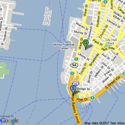
The URL of this image would be (with line breaks added):
http://maps.google.com/staticmap?
center=40.709028,-74.018672&
zoom=14&
size=400x400&
maptype=mobile&
markers=40.702147,-74.015794,blues
        %7C40.711614,-74.012318,greeng&
key=YOURKEY
YOURKEY would be your personal Maps API key which you need to sign up for.
At first look, the Static Maps API seems like a nice alternative to the full-blown JavaScript API – it's not interactive, but a little more accessible.
[Via Google's Lat Long blog.]
*However, there's a "query limit" of "1000 unique image requests per user per day," Google says (disclaiming that "additional requests of an identical image, in general, do not count towards this limit beyond the original request"). It's not made 100% clear how Google counts this, but depending on the type of use this may mean you need to add caching.
Update: If you don't want to create the URL manually, there's a wizard available. [Via Google Operating System.]
>> More posts
Advertisement
This site unofficially covers Google™ and more with some rights reserved. Join our forum!