Thursday, January 18, 2007
Google Removed Sensitive Maps Imagery (Apparently)
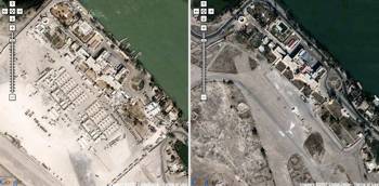
Stefan Geens of the Ogle Earth blog published an impressive piece of digital research that suggests that Google censored some recent satellite imagery in Google Maps/ Google Earth upon government request. What apparently happened is that new satellite imagery from Basra, Iraq, was intentionally replaced with outdated, pre-war imagery, so that it’s of not much help to fighters attacking the US/ British/ ... troops. A UK Telegraph article cites a British military spokesman ...
There is a constant threat of reconnaissance missions to access our bases and using these internet images is just another method of how this is conducted.
... and Google responds:
We have opened channels with the military in Iraq but we are not prepared to discuss what we have discussed with them. But we do listen and we are sensitive to requests.
[Via Googling Google.]
>> More posts
Advertisement
This site unofficially covers Google™ and more with some rights reserved. Join our forum!