Friday, March 30, 2007
Google Geoday Benelux 2007
 Twan Eikelenboom from the Netherlands is currently studying Media & Culture at the University of Amsterdam. He has a special interest in “navigating and exploring this seemingly endless space that new media realities give us.”
 When the invitation for the Benelux Google Geoday 2007, shaped in the form of the Google Maps marker which has risen to fame in the past years, landed in my mailbox it promised to become an interesting day in Amsterdam’s EXPO XXI this Thursday. With presentations by Bernhard Seefeld (Google/Endoxon), Brandon Badger (Google) and Remco Kouwenhoven (Nederkaart) in the morning and workshops on Google Earth and the Google Maps API in the afternoon. With a big thanks to the people at Generation Next who were responsible for my ticket in the first place.
Google’s Geo development (Google Earth and Google Maps) has taken a big step in the previous years, with the coming of Earth and Maps there is a definite focus on adding layer after layer of information on the globe. Like graffiti on a wall everyone can apply meanings to the maps made available by the Google Geo team. As Lev Manovich noticed in The Poetics of Augmented Space: Learning from Prada when talking about Augmented Space: The 90s were about the virtual, the 2000s will probably be about the physical. Not the infinite Internet, but the finite space of the physical land. And it seems that Google eagerly agrees with this prophecy. Below is my account of the day.
Keynote by Bernhard Seefeld
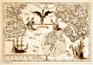
Dangerous dragons were used in the early days of mapping if parts of the map were not known yet to the cartographer. This is one of the examples Seefeld uses from the early mapping practices, which stands for the improving of the image and the filling of the gaps. The early cartographers did not have the information to fill in the holes so they just drew dragons. Another example given is the map of New Holland, or what is now called Australia. The interesting thing is that the Portuguese probably reached this land first, but the Dutch were the first to draw a map of it and therefore being ’responsible’ for the discovery of the land (a discovery from a Western perspective, anyway, as the Aboriginees were already there).
 Seefeld takes the first example and also the mapping of New Holland, which was not accurate at first to say the least as the shape of the land on this image shows, to the present. He notices that the Google Geo team faces a similar situation in pasting together the best available satellite imagery to create the globe of Google Earth. Sometimes the information is available, sometimes not and in that case lesser detailed imagery has to be used. It is not about drawing dragons, but about improving satellite images.
So now we have an explanation of Google’s basemap philosophy, pasting together a globe in a way that perhaps reminds us of the patched body of Frankenstein’s monster. Building on top of that basemap is the next step and this is also the core of the Google Geo team’s stated mission: Organize the world’s geographic information and make it universally accessible and usable. Which is derived from Google’s overall mission statement, which is actually the same but doesn’t include the term geographic.
 Instead of discovering new land, like in the age of navigation and in the second example given above, the user is now able to discover new information, the era of the information age. The emphasis here was especially on the enhanced content applied to the base like web links, reviews of places, photographs and featured content. Seefeld actually went as far as too say that the base is nice and the content makes it great. The base is always the same, just like the physical. But it is information and meanings applied to the physical space that make it what it is. The new idea is that meaning is applied with the use of the virtual, leaving aside the physical. Through the geo applications, new discoveries can be done in the physical space. As an example Seefeld showed the Google ant; a species that got discovered with the help of geo applications.
But all this information applied to the surface of the earth requires a way to search the information. This is the territory of the spatial web, which is all about geotagging, KML and more. Making the meanings applied to the earth searchable. But nowadays discovering the earth isn’t as dangerous as it used to be. The dragons are gone; discovery has become a safe practice. Boring? Perhaps. You can always try the navigation option in Google Maps and Earth and follow the directions, even if it asks you to swim across the Atlantic Ocean.
 What is fascinating is the applying of so many meanings to the finite globe with the help of this virtual reality. I asked Seefeld the question what his views are on potential conflicting meanings. He emphasized the role of the user and also said that it is important to have access to all opinions. Getting everything 100% true is very difficult but the goal is to fix it again and again until it is good, with the help of user opinions. This really reminded me of the already infamous Wikipedia wars, which are more about events, persons, etc. while Google Earth is about space and meaning. As Dorling & Fairbairn say in the chapter Alternative Views from their book Mapping: Ways of Representing the World: “Maps have always presented pictures of ’truth’ and just as many people have many different truths, so there are many maps to be drawn.”
“From API to mashup” by Brandon Badger
The key to presenting all these various views on planet earth and what a website developer can show his/her visitor are mashups. Using the base map and applying content, meaning, to it. Badger emphasizes the essential role of the user and giving us a rather simple and commercial equation: Google’s tools + You = Victory. A more convincing model for the concept of the mashup was that the sum of its parts is greater than the whole: 1 + 1 = 2,53542. I guess it is a good thing Time magazine named us as persons of the year, but it also makes us a lot busier with supplying content for Web2.0 applications. When will “we” get too busy with supplying content until the point that we don’t want to do it anymore? It will probably mark the end of Web2.0: The death of the user.
Mashups by Remco Kouwenhoven
On his website Nederkaart.nl Remco Kouwenhoven shows lots of examples of mashups with the use of the Google Maps API. He showed us some of these on the screen, but the one that struck me the most was this map about the air traffic above Schiphol. What it intends to show is the high density of airplanes at Schiphol airport paired with complaints about the noise.

This reminded me of a remark by Mark Monmonier in the Dorling & Fairbairn piece I already mentioned above: “Cartographic propaganda can be an effective intellectual weapon against an unresponsive, biased, or corrupt bureaucracy.” These mashups can provide this cartographic propaganda in real-time. Current issues can be addressed with the help of real-time information gathering. On Kouwenhoven’s website a lot more examples can be seen and it is a definitely worth browsing and importing some of the examples into Google Earth.
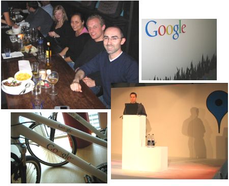
More impressions from the Geoday and Google’s Amsterdam office (with Google bikes) courtesy of Remco Kouwenhoven.
The Workshops
After a morning of presentations the afternoon was reserved for us, the user, to start creating content using the tools supplied by Google as Badger pointed out. Although I’m not sure for how long these links will be online you can check out the small assignments of the workhops at these links: Google Earth workshop and Google Maps API workshop. More technical info is also available through code.google.com. There was one jawdropping example in the Google Earth workshop that I didn’t know about, which is an incredibly detailed 3D city model of Berlin. Definitely a must-see.

After spending two hours being immersed in the representation of the physical space on the screen, the pavement on my way to the train station also had some new meaning applied to it. A strange awareness of how easy meaning can be applied to the physical space we navigate each day, or to the places where we live. Being unaware which meaning has been applied in the virtual to the places we call home. What also struck me after this day is the dependence of Google on the user, who is responsible for supplying the content. It makes you think, but for some reason I’m just feeling lucky right now.
>> More posts
Advertisement
This site unofficially covers Google™ and more with some rights reserved. Join our forum!